Explore the Best Cycling Routes in Las Vegas
Welcome to the GVC Route Library — your go-to resource for the best cycling routes in Las Vegas, Henderson, Boulder City, Red Rock, and the surrounding desert and mountain ranges. Our local riders have curated and verified these routes so you can ride with confidence, knowing you’re following the same roads and climbs enjoyed by the Southern Nevada cycling community every week.
Use the filters below to narrow routes by distance, elevation gain, difficulty level, start location, category, or terrain. Whether you’re training for a big event, building climbing strength, or just looking for a scenic weekend ride, this library makes it easy to find the perfect match.
From iconic climbs like Mount Charleston, Red Rock Scenic Loop, and River Mountain Trail to beautiful endurance routes through Boulder City, Lake Mead, and the Las Vegas Valley, this page is designed to help you plan your next adventure with just a few clicks.
Browse, filter, and explore — then get out and ride!
Start Location
Difficulty

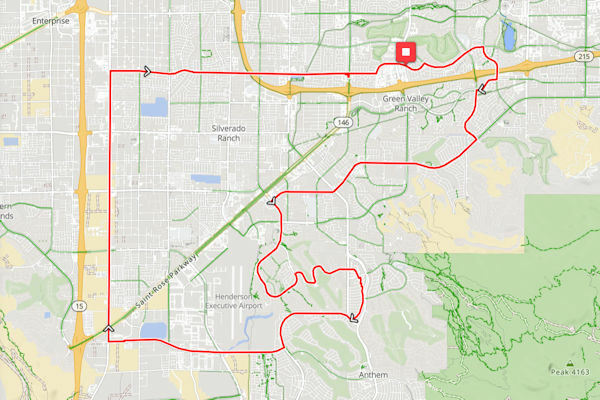
Scenic Ridge Loop
Varied terrain with scenic stretches; good pavement and shoulder in most sections.
- Distance:
- 52 miles
- Elevation:
- 3,380 ft
- Duration:
- 3:28
- Difficulty:
- Intermediate
- Category:
- A
- Start:
- Location 1
- Season:
- All year
View Route
McRide Volunteer
Some moderate climbing; good pavement and shoulder in most sections.
- Distance:
- 27.4 miles
- Elevation:
- 1,220 ft
- Duration:
- Difficulty:
- Intermediate
- Category:
- B,C
- Start:
- Pebble Mktpl.
- Season:
- All year
View Route
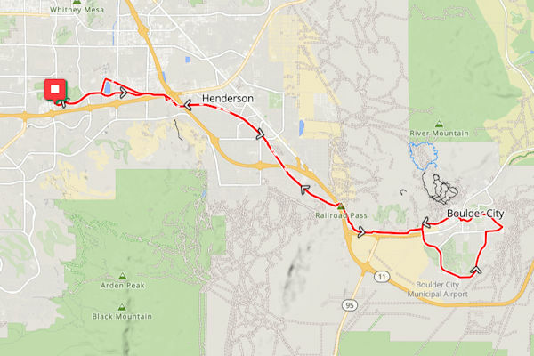
Boulder City with Airport Loop
Varied terrain with scenic stretches; good pavement and shoulder in most sections.
- Distance:
- 37.9 miles
- Elevation:
- 1,520 ft
- Duration:
- Difficulty:
- Intermediate
- Category:
- B,C
- Start:
- Pebble Mktpl.
- Season:
- All year
View Route

Split Ends with Pilot Rd. & Via Nobila
Varied terrain with scenic stretches; good pavement and shoulder in most sections.
- Distance:
- 32.4 miles
- Elevation:
- 870 ft
- Duration:
- Difficulty:
- Intermediate
- Category:
- A,B,C
- Start:
- Mtn. View Park
- Season:
- All Year
View Route

Summit Push
Varied terrain with scenic stretches; good pavement and shoulder in most sections.
- Distance:
- 105 miles
- Elevation:
- 8,100 ft
- Duration:
- 7:30
- Difficulty:
- Expert
- Category:
- A
- Start:
- Location 5
- Season:
- May–October
View Route

Valley Traverse
Varied terrain with scenic stretches; good pavement and shoulder in most sections.
- Distance:
- 36 miles
- Elevation:
- 1,980 ft
- Duration:
- 2:24
- Difficulty:
- Intermediate
- Category:
- B,C
- Start:
- Location 1
- Season:
- November–April
View Route

Mesa Overlook
Varied terrain with scenic stretches; good pavement and shoulder in most sections.
- Distance:
- 31 miles
- Elevation:
- 1,860 ft
- Duration:
- 2:04
- Difficulty:
- Intermediate
- Category:
- B,C,D
- Start:
- Location 2
- Season:
- All year
View Route

Riverbend Route
Varied terrain with scenic stretches; good pavement and shoulder in most sections.
- Distance:
- 24 miles
- Elevation:
- 1,020 ft
- Duration:
- 1:36
- Difficulty:
- Beginner
- Category:
- C,D
- Start:
- Location 3
- Season:
- March–November
View Route

Pioneer Pass
Varied terrain with scenic stretches; good pavement and shoulder in most sections.
- Distance:
- 120 miles
- Elevation:
- 9,000 ft
- Duration:
- 8:34
- Difficulty:
- Expert
- Category:
- A
- Start:
- Location 4
- Season:
- October–April
View Route

Saddleback Sweep
Varied terrain with scenic stretches; good pavement and shoulder in most sections.
- Distance:
- 38 miles
- Elevation:
- 1,520 ft
- Duration:
- 2:32
- Difficulty:
- Intermediate
- Category:
- B,C
- Start:
- Location 5
- Season:
- May–October
View Route

High Desert Drift
Varied terrain with scenic stretches; good pavement and shoulder in most sections.
- Distance:
- 47 miles
- Elevation:
- 2,630 ft
- Duration:
- 3:08
- Difficulty:
- Intermediate
- Category:
- A,B
- Start:
- Location 1
- Season:
- All year
View Route

Quartz Ridge Run
Varied terrain with scenic stretches; good pavement and shoulder in most sections.
- Distance:
- 29 miles
- Elevation:
- 1,240 ft
- Duration:
- 1:56
- Difficulty:
- Beginner
- Category:
- C,D
- Start:
- Location 2
- Season:
- September–May
View Route

Juniper Ascent
Varied terrain with scenic stretches; good pavement and shoulder in most sections.
- Distance:
- 76 miles
- Elevation:
- 5,470 ft
- Duration:
- 5:26
- Difficulty:
- Advanced
- Category:
- A
- Start:
- Location 3
- Season:
- October–April
View Route

Sagebrush Tour
Varied terrain with scenic stretches; good pavement and shoulder in most sections.
- Distance:
- 33 miles
- Elevation:
- 1,650 ft
- Duration:
- 2:12
- Difficulty:
- Intermediate
- Category:
- B,C
- Start:
- Location 4
- Season:
- March–November
View Route

Old Mill Loop
Varied terrain with scenic stretches; good pavement and shoulder in most sections.
- Distance:
- 26 miles
- Elevation:
- 980 ft
- Duration:
- 1:44
- Difficulty:
- Beginner
- Category:
- A,B
- Start:
- Location 5
- Season:
- All year
View Route

Echo Canyon Way
Varied terrain with scenic stretches; good pavement and shoulder in most sections.
- Distance:
- 48 miles
- Elevation:
- 3,120 ft
- Duration:
- 3:12
- Difficulty:
- Intermediate
- Category:
- B,C
- Start:
- Location 1
- Season:
- November–April
View Route

Painted Rock Ride
Varied terrain with scenic stretches; good pavement and shoulder in most sections.
- Distance:
- 120 miles
- Elevation:
- 9,400 ft
- Duration:
- 8:34
- Difficulty:
- Expert
- Category:
- A
- Start:
- Location 2
- Season:
- May–October
View Route

Willow Springs
Varied terrain with scenic stretches; good pavement and shoulder in most sections.
- Distance:
- 33 miles
- Elevation:
- 1,540 ft
- Duration:
- 2:12
- Difficulty:
- Intermediate
- Category:
- B,C
- Start:
- Location 3
- Season:
- All year
View Route

Sunrise Spur
Varied terrain with scenic stretches; good pavement and shoulder in most sections.
- Distance:
- 22 miles
- Elevation:
- 920 ft
- Duration:
- 1:32
- Difficulty:
- Beginner
- Category:
- C,D
- Start:
- Location 4
- Season:
- September–May
View Route

Skyline Climb
Varied terrain with scenic stretches; good pavement and shoulder in most sections.
- Distance:
- 86 miles
- Elevation:
- 6,100 ft
- Duration:
- 5:44
- Difficulty:
- Advanced
- Category:
- A
- Start:
- Location 5
- Season:
- October–April
View Route

Red Bluff Circuit
Varied terrain with scenic stretches; good pavement and shoulder in most sections.
- Distance:
- 40 miles
- Elevation:
- 1,780 ft
- Duration:
- 2:30
- Difficulty:
- Intermediate
- Category:
- B,C
- Start:
- Location 1
- Season:
- All year
View Route

Boulder Wash
Varied terrain with scenic stretches; good pavement and shoulder in most sections.
- Distance:
- 27 miles
- Elevation:
- 1,040 ft
- Duration:
- 1:48
- Difficulty:
- Beginner
- Category:
- A,B
- Start:
- Location 2
- Season:
- March–November
View Route

Coyote Pass
Varied terrain with scenic stretches; good pavement and shoulder in most sections.
- Distance:
- 95 miles
- Elevation:
- 7,400 ft
- Duration:
- 6:52
- Difficulty:
- Advanced
- Category:
- A
- Start:
- Location 3
- Season:
- November–April
View Route

Aspen Gate
Varied terrain with scenic stretches; good pavement and shoulder in most sections.
- Distance:
- 34 miles
- Elevation:
- 1,760 ft
- Duration:
- 2:16
- Difficulty:
- Intermediate
- Category:
- B,C
- Start:
- Location 4
- Season:
- All year
View Route

Badger Bend
Varied terrain with scenic stretches; good pavement and shoulder in most sections.
- Distance:
- 20 miles
- Elevation:
- 860 ft
- Duration:
- 1:20
- Difficulty:
- Beginner
- Category:
- C,D
- Start:
- Location 5
- Season:
- September–May
View Route

Stone Archway
Varied terrain with scenic stretches; good pavement and shoulder in most sections.
- Distance:
- 66 miles
- Elevation:
- 4,150 ft
- Duration:
- 4:50
- Difficulty:
- Advanced
- Category:
- A
- Start:
- Location 1
- Season:
- March–November
View Route

Ridge & Ravine
Varied terrain with scenic stretches; good pavement and shoulder in most sections.
- Distance:
- 58 miles
- Elevation:
- 3,770 ft
- Duration:
- 3:52
- Difficulty:
- Advanced
- Category:
- A,B
- Start:
- Location 2
- Season:
- October–April
View Route

Plateau Path
Varied terrain with scenic stretches; good pavement and shoulder in most sections.
- Distance:
- 35 miles
- Elevation:
- 1,900 ft
- Duration:
- 2:20
- Difficulty:
- Intermediate
- Category:
- B,C
- Start:
- Location 3
- Season:
- All year
View Route

Windbreak Way
Varied terrain with scenic stretches; good pavement and shoulder in most sections.
- Distance:
- 18 miles
- Elevation:
- 740 ft
- Duration:
- 1:14
- Difficulty:
- Beginner
- Category:
- B,C,D
- Start:
- Location 4
- Season:
- September–May
View Route

Raven’s Roost
Varied terrain with scenic stretches; good pavement and shoulder in most sections.
- Distance:
- 72 miles
- Elevation:
- 5,050 ft
- Duration:
- 5:09
- Difficulty:
- Advanced
- Category:
- A
- Start:
- Location 5
- Season:
- March–November
View Route

Ironwood Circuit
Varied terrain with scenic stretches; good pavement and shoulder in most sections.
- Distance:
- 44 miles
- Elevation:
- 2,260 ft
- Duration:
- 2:45
- Difficulty:
- Intermediate
- Category:
- B,C
- Start:
- Location 1
- Season:
- All year
View Route

Gale Ridge
Varied terrain with scenic stretches; good pavement and shoulder in most sections.
- Distance:
- 30 miles
- Elevation:
- 1,420 ft
- Duration:
- 2:00
- Difficulty:
- Intermediate
- Category:
- A,B
- Start:
- Location 2
- Season:
- October–April
View Route

Cathedral Wash
Varied terrain with scenic stretches; good pavement and shoulder in most sections.
- Distance:
- 112 miles
- Elevation:
- 9,900 ft
- Duration:
- 8:00
- Difficulty:
- Expert
- Category:
- A
- Start:
- Location 3
- Season:
- May–October
View Route

Outlaw Loop
Varied terrain with scenic stretches; good pavement and shoulder in most sections.
- Distance:
- 41 miles
- Elevation:
- 1,900 ft
- Duration:
- 2:34
- Difficulty:
- Intermediate
- Category:
- B,C
- Start:
- Location 4
- Season:
- All year
View Route

Needle Point
Varied terrain with scenic stretches; good pavement and shoulder in most sections.
- Distance:
- 16 miles
- Elevation:
- 620 ft
- Duration:
- 1:08
- Difficulty:
- Beginner
- Category:
- B,C,D
- Start:
- Location 5
- Season:
- March–November
View Route

Sierra Vista
Varied terrain with scenic stretches; good pavement and shoulder in most sections.
- Distance:
- 88 miles
- Elevation:
- 6,600 ft
- Duration:
- 5:52
- Difficulty:
- Advanced
- Category:
- A
- Start:
- Location 1
- Season:
- October–April
View Route

Brimstone Rise
Varied terrain with scenic stretches; good pavement and shoulder in most sections.
- Distance:
- 54 miles
- Elevation:
- 3,650 ft
- Duration:
- 3:36
- Difficulty:
- Advanced
- Category:
- A,B
- Start:
- Location 2
- Season:
- All year
View Route

Prairie Star
Varied terrain with scenic stretches; good pavement and shoulder in most sections.
- Distance:
- 32 miles
- Elevation:
- 1,540 ft
- Duration:
- 2:08
- Difficulty:
- Intermediate
- Category:
- B,C
- Start:
- Location 3
- Season:
- September–May
View Route

Thunder Mesa
Varied terrain with scenic stretches; good pavement and shoulder in most sections.
- Distance:
- 25 miles
- Elevation:
- 1,000 ft
- Duration:
- 1:40
- Difficulty:
- Beginner
- Category:
- C,D
- Start:
- Location 4
- Season:
- March–November
View Route

Blackrock Grade
Varied terrain with scenic stretches; good pavement and shoulder in most sections.
- Distance:
- 98 miles
- Elevation:
- 7,200 ft
- Duration:
- 7:00
- Difficulty:
- Advanced
- Category:
- A
- Start:
- Location 5
- Season:
- October–April
View Route

Golden Hour Loop
Varied terrain with scenic stretches; good pavement and shoulder in most sections.
- Distance:
- 22 miles
- Elevation:
- 880 ft
- Duration:
- 1:32
- Difficulty:
- Beginner
- Category:
- A,B
- Start:
- Location 1
- Season:
- All year
View Route

Hawk’s Landing
Varied terrain with scenic stretches; good pavement and shoulder in most sections.
- Distance:
- 57 miles
- Elevation:
- 3,480 ft
- Duration:
- 3:48
- Difficulty:
- Advanced
- Category:
- A,B
- Start:
- Location 2
- Season:
- September–May
View Route

Switchback Alley
Varied terrain with scenic stretches; good pavement and shoulder in most sections.
- Distance:
- 45 miles
- Elevation:
- 2,520 ft
- Duration:
- 2:48
- Difficulty:
- Intermediate
- Category:
- B,C
- Start:
- Location 3
- Season:
- March–November
View Route

Oasis Traverse
Varied terrain with scenic stretches; good pavement and shoulder in most sections.
- Distance:
- 28 miles
- Elevation:
- 1,160 ft
- Duration:
- 1:52
- Difficulty:
- Beginner
- Category:
- C,D
- Start:
- Location 4
- Season:
- All year
View Route

Miner’s Cut
Varied terrain with scenic stretches; good pavement and shoulder in most sections.
- Distance:
- 60 miles
- Elevation:
- 3,900 ft
- Duration:
- 4:00
- Difficulty:
- Advanced
- Category:
- A
- Start:
- Location 5
- Season:
- October–April
View Route

Cottonwood Lane
Varied terrain with scenic stretches; good pavement and shoulder in most sections.
- Distance:
- 36 miles
- Elevation:
- 1,820 ft
- Duration:
- 2:24
- Difficulty:
- Intermediate
- Category:
- B,C
- Start:
- Location 1
- Season:
- September–May
View Route

Rimrock Roller
Varied terrain with scenic stretches; good pavement and shoulder in most sections.
- Distance:
- 200 miles
- Elevation:
- 12,000 ft
- Duration:
- 14:17
- Difficulty:
- Expert
- Category:
- A
- Start:
- Location 2
- Season:
- May–October
View Route

Silver Gulch
Varied terrain with scenic stretches; good pavement and shoulder in most sections.
- Distance:
- 50 miles
- Elevation:
- 3,250 ft
- Duration:
- 3:20
- Difficulty:
- Intermediate
- Category:
- A,B
- Start:
- Location 3
- Season:
- All year
View Route

Trailhead Circuit
Varied terrain with scenic stretches; good pavement and shoulder in most sections.
- Distance:
- 39 miles
- Elevation:
- 1,930 ft
- Duration:
- 2:36
- Difficulty:
- Intermediate
- Category:
- B,C
- Start:
- Location 4
- Season:
- November–April
View Route

Pine Canyon
Varied terrain with scenic stretches; good pavement and shoulder in most sections.
- Distance:
- 62 miles
- Elevation:
- 4,030 ft
- Duration:
- 4:08
- Difficulty:
- Advanced
- Category:
- A
- Start:
- Location 5
- Season:
- September–May
View Route
No routes match your filters.